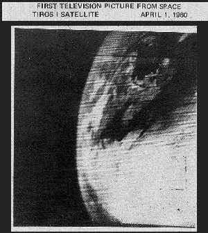
Weather from space turns 50
Fifty years ago today, the world’s first weather satellite lifted off from Cape Canaveral, Fla., reports the National Oceanic and Atmospheric Administration.
Not even a blown April Fools rain forecast for Los Angeles can suppress the jubilation at NOAA, which adds: “The first image from the satellite, known as TIROS-1 (Television Infrared Observation Satellite), was a fuzzy picture of thick bands and clusters of clouds over the United States. An image captured a few days later revealed a typhoon about a 1,000 miles east of Australia.”
TIROS-1, (NASA photo left) a polar-orbiting satellite that lasted 78 days, weighed 270 pounds and carried two cameras and two video recorders.
Below, as contrast, is a March 2010 NASA satellite image of Tropical Cyclone Paul, posted today at NASA’s Earth Observatory. This was taken by the Aqua satellite, launched in May 2002 as part of a project to better understand the …
High good, low bad: Mead in March 2010
There is a joke that my father, a former aerospace engineer, used to tell that applies equally well to water as to planes. There is a jolt on a jet and the pilot announces that the plane has lost one engine but still has three more. They will be a half an hour late landing. Soon, there is a second jolt and the pilot announces that another engine has failed, but they still have two engines and will be an hour late landing. After a third jolt brings the announcement that they still have one engine and will be an hour and a half late landing, an engineer from the cabin cries, “If the fourth engine goes, we’ll be up here all night!”
Water wise, in spite of a mild El Nino winter, it looks like the West may be up here all night. The level of Lake Mead, the …
« go backNorth American Native Plant Societies

After the lawn

Garden blogs
