Image of the day: Mediterranean climate zones
THIS image of the day from NASA’s Earth Observatory takes composite pictures of global cloud cover for the month of October 2009 to examine what cloud presence alone says about the land below.
According to NASA, the starkest examples are in areas where dry land is bordered by ocean. Sure enough, peeping out from beneath the clouds are the world’s five mediterranean climate zones, which in addition to California include part of the Chilean coast into western Argentina, southwestern Australia, the Mediterranean basin and southwestern South Africa.
Mediterranean climate zones have unique floras adapted to surviving on winter rains then hunkering down into dormancy during prolonged dry seasons. For Californians, who for the last century have grown wet-climate plants such as turf grass with imported water, a switch to native and mediterranean climate zone plants is seen as an essential step as global warming and population growth threaten the …
El Nino: “A slight tilt in the odds” for California
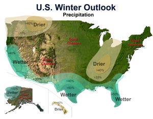
THE NATIONAL Oceanic and Atmospheric Administration yesterday reiterated forecasts for an El Nino in its seasonal outlook for December-February.
California, it says, has a “slight tilt in the odds toward wetter-than-average conditions over the entire state.”
For the announcement, click here. For Chance of Rain’s chat with JPL oceanographer Bill Patzert on the likelihood of a big rain year, here. For a September 28, 2009 NASA round-up of the debate over whether it will rain much or not in the parched West this winter, click here.…
A good rain
THE NORTH got drenched, but here in Southern California, according to the Los Angeles Times, fine showers and the absence of downpours largely spared the foothill communities from post-fire debris torrents. As of 5pm today, we in downtown Los Angeles had received 2.03 inches of rain that fell steadily last night and in light showers throughout today. For a National Weather Service regional breakdown of who got how much rain where, click here. Isolated showers are forecast for the evening.
For a most interesting diversion, try this article by Keith C. Heidorn, aka “the Weather Doctor,” on why rain drops are not tear-shaped, but round and then as they enlarge, shaped like hamburger buns.
This post has been updated.…
A huge storm is coming to California
Click on the image for the National Weather Service, then enter your location for the latest forecasts.
Via Aquafornia: “I am looking at a storm developing in the eastern Pacific today that made me look at the calendar to confirm it’s still October … a huge storm is coming to a large part of California, especially the northern two thirds.” – Ken Clark, AccuWeather.com. For Clark’s state-wide forecast for California, click here.
For Southern California Clark predicts: Rainfall amounts of 2 to 4 inches are likely in western Santa Barbara County to 1.5 to 2.5 inches in Ventura County, 0.75 to 1.50 in the LA Basin diminishing to 0.10 to 0.30 inches in San Diego County. These are total rain amounts through Wednesday as a few showers linger behind the main rain band.
For the deserts: Some rain …
Rain in Los Angeles
- Thursday sunny, high 80F
Click on the icons to be taken to the National Weather Service. This post was last updated at 6.40pm, October 13th, 2009.…
« go back — keep looking »North American Native Plant Societies

After the lawn

Garden blogs
