Colorado “most endangered” American river
The Colorado tops 2013 "most endangered" list from American Rivers‘Irene has a long reach’
Six years to the week of Hurricane Katrina, “Irene has a long reach,” reports NASA’s Earth Observatory. “The storm is large, spanning nearly 1,000 kilometers (600 miles) from east to west in this image (below). It could intensify slightly in the next day or two. The storm’s currently forecasted track takes it over the Outer Banks and along the U.S. East Coast before going ashore over New England.” Click here to be taken to NASA, here for NOAA’s National Hurricane Center. UPDATE: Click here for the Washington Post’s live hurricane tracker.…
El Nino intensified in November, NASA reports
OCEAN conditions known as ‘El Nino’ and associated with wet winters in California intensified in November, reports the NASA Earth Observatory today. For a satellite photo of this week’s storm, click here.
For National Weather Service forecasts of continuing rain, click here. For preliminary rainfall amounts in greater Los Angeles from last night’s showers, here.
Elsewhere around the world and the web, the New York Times has a simple, informative interactive map showing which countries are at the United Nations Climate Conference in Copenhagen and what they seek. To access it, click here. For a Los Angeles Times update from the negotiating floor, click here. For Day 5 of the Copenhagen conferenc…
Secret of vanishing water
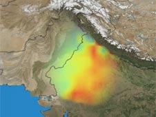
NASA's Grace satellites measured the depletion of groundwater in northwestern India between 2002 and 2008. Image: NASA/Trent Schindler and Matt Rodell
PASADENA, Calif, from the Jet Propulsion Laboratory: Using NASA satellite data, scientists have found that groundwater levels in northern India have been declining by as much as 33 centimeters (1 foot) per year over the past decade. Researchers concluded the loss is almost entirely due to human activity. For the full story, click here.…
Central Valley, observed
THANKS to Aquafornia, the news feed for the Water Education Foundation, for catching this NASA image from the Earth Observatory. From NASA: The image was made from data collected by NASA’s Terra satellite between July 12 and July 27, 2009. This image shows how vegetation fared in 2009 compared to 2000 and 2008. To see a larger image with key and to read an excellent accompanying article, click here.…
keep looking »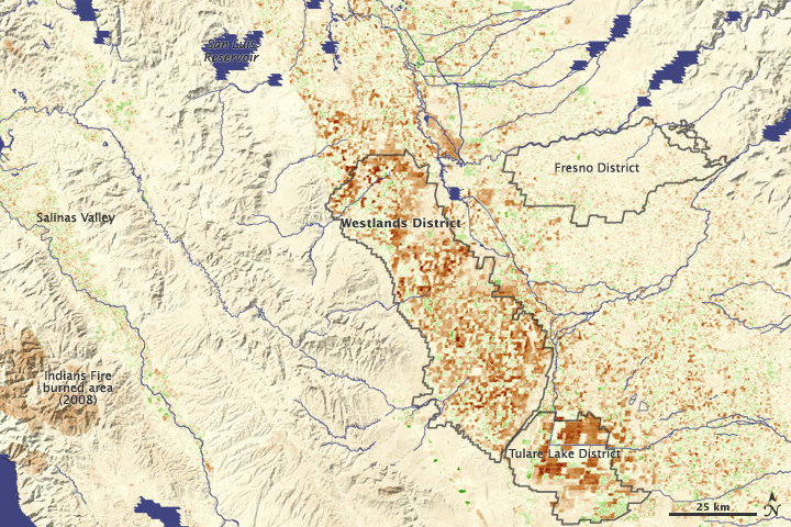
North American Native Plant Societies

After the lawn

Garden blogs
