Map of plume from Japan
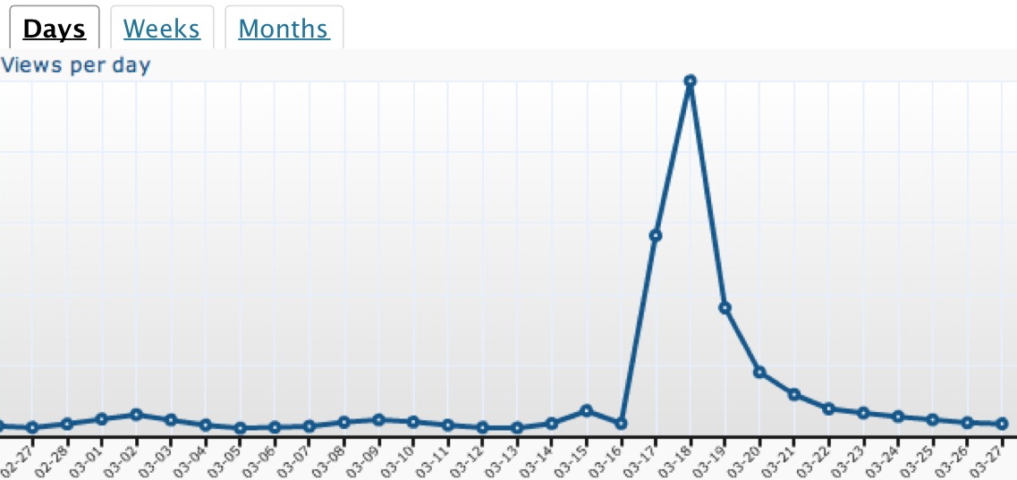
UPDATED POST: A Comprehensive Test Ban Treaty Organization model of radioactive material from the disaster in Japan carried in the New York Times and Los Angeles Times has been removed from this post. Comments relating to the map have been removed. Anyone wishing to comment should go to those papers. This website, whose core mission is conservation, was being overwhelmed (see graphic above). For information about trace radiation in California from the Japan disaster, by all means check your air quality management district. Or check daily radiation levels from this RadNet Service from the US Environmental Protection Agency. No further comments to do with this remaining stub post will be published and earlier comments have been stricken.
March 25: National Public Radio has this excellent story about the Comprehensive Test Ban Treaty Organization monitoring, Built for bombs, Sensors now track Japan radiation.…
Notable fountains
Click here, or on the fountain of your choice, to be taken to day’s splendid piece of Op-Art in the New York Times.…
“Daylighting” urban rivers
FROM THE New York Times science blog Dot Earth comes this Yonkers Historical Society 1920s photograph of a giant flume being run where the Saw Mill River used to flow. Now, according to a story by Andrew C. Revkin, Yonkers is trying to unbury the river to create a greenway.
For Revkin’s blog on movements around the world, including in Los Angeles, to “daylight” buried or paved rivers, click here.
For information about moves to restore the Los Angeles River, click here.…
North American Native Plant Societies

After the lawn

Garden blogs
