High good, low bad: Mead in February 2011
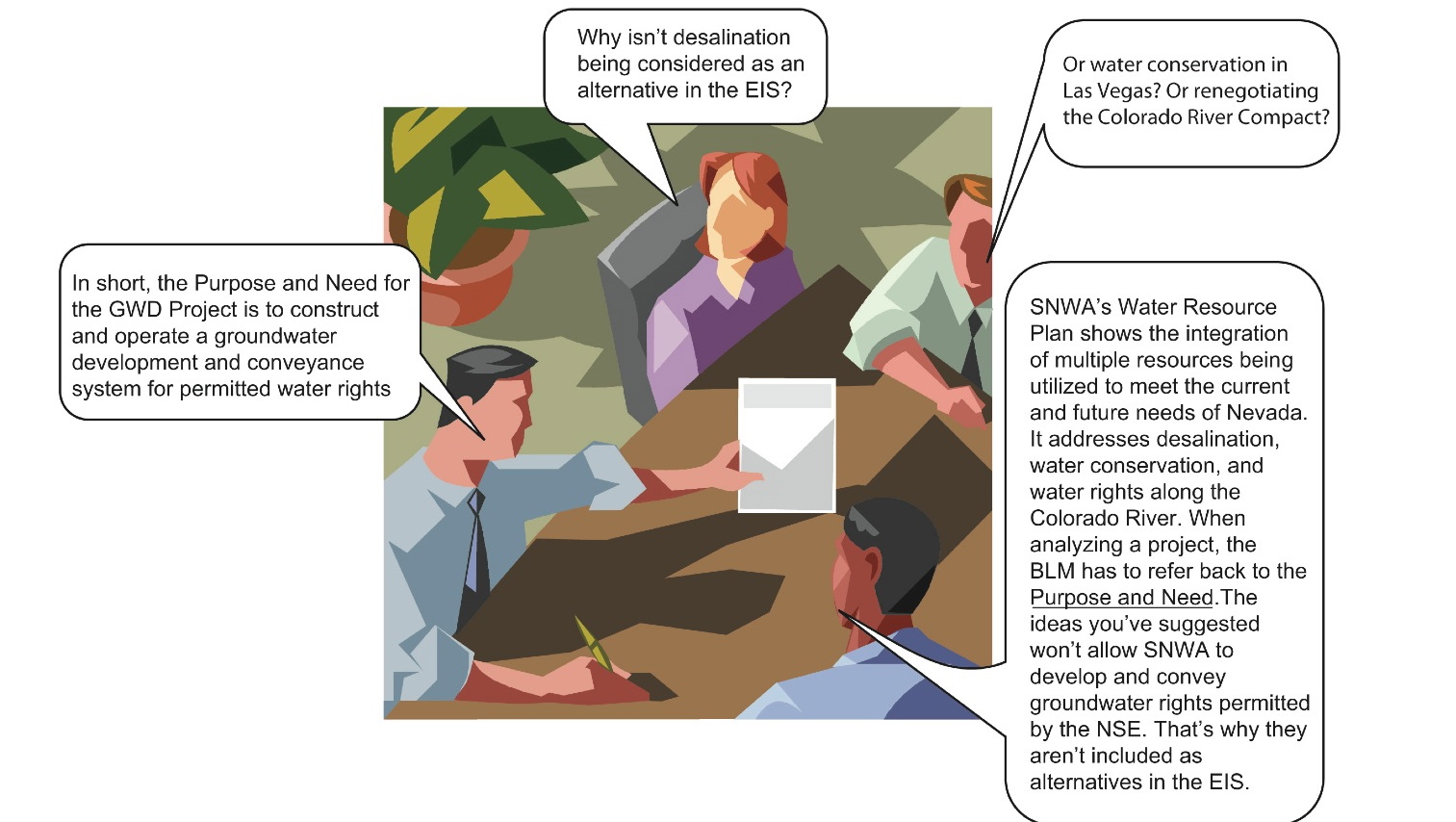
Actionful and remarkably well-groomed bureaucrats: Bureau of Land Management illustration explaining what might appear a Southern Nevada Water Authority-friendly bent in the framing of the pending Environmental Impact Statement. Click on the image to read the captions.
Two decades ago, a plan to tap the Great Basin Aquifer in five Nevada valleys through a nearly 300-mile-long pipeline to slake inexorably booming Las Vegas was a back-up plan. Plan A was that Nevada’s relatively small allocation from the Colorado River could be increased. Las Vegas is, after all, twenty miles from Lake Mead, the largest storage reservoir in the U.S.
Yet when Western cities kept booming after the Colorado River entered long-term drought in 1991, Plan B became Plan A. Tapping the aquifer of the glorious and sparsely populated counties of Nevada’s Great Basin Desert became a central pillar of the Southern Nevada Water Authority’s long term water plan. Steve …
High good, low bad: Mead in January 2011
The Economist is the latest migratory Eastern (English this time) high flier to take a pass over Lake Mead and notice the “bathtub ring,” then to quote Las Vegas water manager Pat Mulroy, who said that Southern Nevada is the “canary in the mine shaft” of western water scarcity. That would be true if canaries were the ones running the mines. Anyway, as far as January on the Colorado River went, a far more interesting story appeared last month in the Las Vegas Review-Journal, which reported that work on the “starter tunnel” for the “third straw” for Las Vegas to draw water from an ever-shallower Lake Mead will need to begin afresh because of persistent flooding problems. Click here to read Henry Brean’s report.
Meanwhile, for those who follow such things, Lake Mead closed at 1,091.73 feet, or thereabouts. By way of characterization, suffice it to say that the elevation …
High good, low bad: Mead in December 2010
The good news in the last hour of 2010 was that Lake Mead was 4.36 feet higher than the closing elevation for November. The bad news is that a winter bump is not unusual and, at ten feet lower than the closing December elevation for 2009 and at 40% capacity, the main storage reservoir on the Colorado River is 11.3 feet above a level that will trigger cuts for Arizona and Nevada.
Nerves are bad enough in the Grand Canyon State that the Arizona Republic reported this week that water managers are considering leaving part of their 2011 Colorado River allocation in Mead to forestall mandatory cuts. Larry Dozier, deputy general manager of the Central Arizona Project, told the Republic: “If we leave a little water this year, we won’t take the bigger hit the next year. Then we can take another spin on …
High good, low bad: Mead in September 2010
Seventy five years ago, President Franklin Delano Roosevelt dedicated Hoover Dam. The concrete is looking good. The thing showing its age is the Colorado River water impounded behind it. The elevation of Lake Mead, the storage reservoir serving California, Arizona, Nevada and the Republic of Mexico, dropped last night to 1,083.83 feet, the lowest closing elevation for September since 1937. That year, the world’s then largest reservoir was still filling. Now its over-allocated water is steadily disappearing. Elsewhere in the Bad News Department, the river serving it is unlikely to be flush this coming winter according to a new study comparing drought stress evident from tree rings and ocean currents. Rather, in Long-Term Relationships Between Ocean Variability and Water Resources in Northeastern Utah, RAND Corp researcher Abbie Tingstad and UCLA geographer Glen MacDonald suggest…
High good, low bad: Mead in August 2010
There may be a plan in place to keep the West in water in the face of climate change, population growth and sluggishness to conserve. Or there may simply be plans for plans. The image above comes from a federal Bureau of Reclamation May 2010 Tribal outreach PowerPoint to do with supply and demand on the Colorado River.
To quote retired General Stanley A. McChrystal’s remark about another PowerPoint, “When we understand that slide, we’ll have won the war.”
As for the current state of our shrinking Colorado River reserves, with apologies for the lateness of what should have been a September 1 posting, after the jump are the last 10 closing August elevations for the reservoir serving Arizona, Nevada, California and the Republic of Mexico as reported by the master of the river. The closing August 2010 elevation of Lake Mead was 1,086.91, the lowest since 1956. Click here…
« go back — keep looking »North American Native Plant Societies

After the lawn

Garden blogs
