High good, low bad: Mead in March 2010
There is a joke that my father, a former aerospace engineer, used to tell that applies equally well to water as to planes. There is a jolt on a jet and the pilot announces that the plane has lost one engine but still has three more. They will be a half an hour late landing. Soon, there is a second jolt and the pilot announces that another engine has failed, but they still have two engines and will be an hour late landing. After a third jolt brings the announcement that they still have one engine and will be an hour and a half late landing, an engineer from the cabin cries, “If the fourth engine goes, we’ll be up here all night!”
Water wise, in spite of a mild El Nino winter, it looks like the West may be up here all night. The level of Lake Mead, the …
Westlands
AS STAGE armies work Sacramento for their pieces of a proposed $9 plus billion water bill and bond, attorney Lloyd G. Carter would have us wipe some tears from our eyes about the plight of Westlands Water District.
Carter, a former UPI and Fresno Bee reporter, now a deputy in the California Attorney General’s office, has a new article on the subject in the Golden Gate University Environmental Law Journal.
He writes of Westlands in Reaping Riches from a Wretched Region: “federal irrigation and farm-subsidy policy in the San Luis Unit since the 1960s has exacerbated grinding poverty while enriching a few dozen of the factory farming dynasties to the detriment of the environment, the human population of the region, small growers, and the public fisc. There are few farms under 500 acres. Rule is by the rich. Indeed, in Westlands, which is a public agency, the …
High good, low bad: Mead in June
NASA image of the Colorado River Delta in the Gulf of California. Click on image for NASA history of the image and the region.
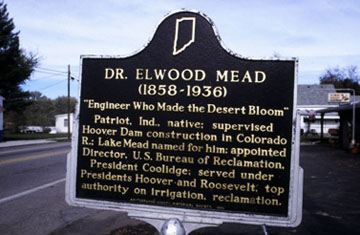
LAKE MEAD is the Colorado River reservoir holding key water supplies for California, Arizona, Nevada and the Republic of Mexico. The remnants of what was once a vast watershed concluding in the Gulf of California now depend on releases of water from Mead.
High Good, Low Bad: May Elevations on Mead
Lake Mead is the Colorado River Reservoir holding water supplies for California, Arizona, Nevada and Mexico. The maximum elevation is 1,229 feet. Below, gleaned from US Bureau of Reclamation records, are year-on-year May elevation reports going back to 2004. Also borrowed from Reclamation is a nifty graphic published on Friday, May 8, 2009 showing April and May 2009 elevations. The May elevations were largely estimates (in yellow). Kudos to the graphic artist. The actual closing elevation for May 31, 2009 was 1,096.92.
DATE ELEVATION OF LAKE MEAD
May 31, 2009: 1,096.92
May 31, 2008: 1,107.05
May 31, 2007: 1,115.89
May 31, 2006: 1,131.14
May 31, 2005: 1,141.89
May 31, 2004: 1,129.70
For April Elevations, click here
…
High Good, Low Bad: Lake Mead Elevations
Source: US Bureau of Reclamation
HOPEFULLY there is more water than silt in the main Colorado River reservoir holding water supplies for California, Arizona, Nevada and Mexico. The maximum elevation for Lake Mead is 1,229 feet. Below, gleaned from US Bureau of Reclamation records, is the first of what will be monthly elevation reports for Lake Mead on this blog, with year on year contrasts going back to 2004. Above, for those who prefer pictures to numbers, also borrowed from Reclamation, is a nifty graphic published on Friday, May 8, 2009 showing April and May 2009 elevations, including predictions (in yellow) throughout the month.
April 30, 2009 1,101.26 ft
April 30, 2008 1,110.61 ft
April 30, 2007 1,120.69 ft
April 30, 2006 1,135.94 ft
April 30, 2005 1,144.45 ft
April 30, 2004 1,134.98 ft
…
« go back — keep looking »North American Native Plant Societies

After the lawn

Garden blogs
