High good, low bad: Mead in September 2010
Seventy five years ago, President Franklin Delano Roosevelt dedicated Hoover Dam. The concrete is looking good. The thing showing its age is the Colorado River water impounded behind it. The elevation of Lake Mead, the storage reservoir serving California, Arizona, Nevada and the Republic of Mexico, dropped last night to 1,083.83 feet, the lowest closing elevation for September since 1937. That year, the world’s then largest reservoir was still filling. Now its over-allocated water is steadily disappearing. Elsewhere in the Bad News Department, the river serving it is unlikely to be flush this coming winter according to a new study comparing drought stress evident from tree rings and ocean currents. Rather, in Long-Term Relationships Between Ocean Variability and Water Resources in Northeastern Utah, RAND Corp researcher Abbie Tingstad and UCLA geographer Glen MacDonald suggest…
High good, low bad: Mead in August 2010
There may be a plan in place to keep the West in water in the face of climate change, population growth and sluggishness to conserve. Or there may simply be plans for plans. The image above comes from a federal Bureau of Reclamation May 2010 Tribal outreach PowerPoint to do with supply and demand on the Colorado River.
To quote retired General Stanley A. McChrystal’s remark about another PowerPoint, “When we understand that slide, we’ll have won the war.”
As for the current state of our shrinking Colorado River reserves, with apologies for the lateness of what should have been a September 1 posting, after the jump are the last 10 closing August elevations for the reservoir serving Arizona, Nevada, California and the Republic of Mexico as reported by the master of the river. The closing August 2010 elevation of Lake Mead was 1,086.91, the lowest since 1956. Click here…
High good, low bad: Mead in July 2010
Photograph: Pete McBride on the parched Colorado River delta, by Jonathan Waterman. Click on the image to be taken to Waterman's Colorado River Project.
During a recent discussion of water at the Aspen Institute’s Environment Forum in Colorado, former Secretary of the Interior Bruce Babbitt told a packed house: “The American Southwest is not one of those regions where there is water scarcity. It’s hard to believe, given all the hyping in the national and local and regional press.”
The audience and his copanelists–Sandra Postel, director of the Global Water Policy Project and freshwater fellow for the National Geographic Society, and Pat Mulroy, general manager of Southern Nevada Water Authority (overseeing Las Vegas water)–were taken aback by these statements, writes Jonathan Waterman in the first of a series of Colorado River notes in National Geographic.
Throughout the Southwest, and particularly in a region that I know, the Colorado River …
High good, low bad: Mead in June 2010
'Colossus' author Michael Hiltzik speculates that Los Angeles Times proprietor Harry Chandler was behind the Hoover administration's hiring of architect Gordon B. Kaufmann to streamline and simplify plans for Boulder (eventually Hoover) Dam. "Early in 1931, Kaufmann began hacking away at Reclamation's architectural scheme (above)," writes Hiltizk, "which was burdened with such neoclassical gingerbread as pediments, elaborate balustrades on the dam crest, and columns capped with bronze eagles." Click on the image to be taken to the Reclamation page about Kaufmann, who also collaborated with the bureau on Parker and Shasta dams.
There is a telling quirk to most US maps of the Colorado River: They stop at the Mexican border. The river’s once-mighty delta and the Sea of Cortez rarely figure.
Save a few forays south, this delineation holds true in the recently published book “Colossus: Hoover Dam and the Making of the American Century“ by Michael …
High good, low bad: Mead in May 2010
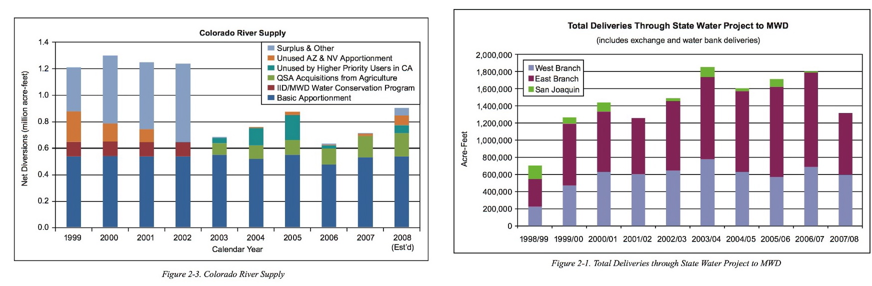
Two graphics from the 2007/2008 Annual Report of the Metropolitan Water District of Southern California (the most recent available) illustrate how water exports from the San Joaquin and Sacramento River Bay Delta (right) rose sharply as surpluses dried up on the Colorado River (left) after 2002. Click on the image to enlarge the graphics.
Eleven years into a dramatic drought* on the Colorado River, in 2009, the City of Los Angeles finally saw fit to issue a lawn watering ordinance that reduced sprinkler irrigation to a twice weekly schedule. It was an overdue and obvious step given that roughly half of Southern California’s water supply is used out of doors, and half of that is estimated to be wasted through sprinkler run-off and pavement hosing.
That ordinance, which took effect a year ago today, reduced the city’s water consumption to 1991 levels even though the law was widely flouted, …
« go back — keep looking »North American Native Plant Societies

After the lawn

Garden blogs
