High good, low bad: Mead in July
Posted on | August 1, 2009 | No Comments
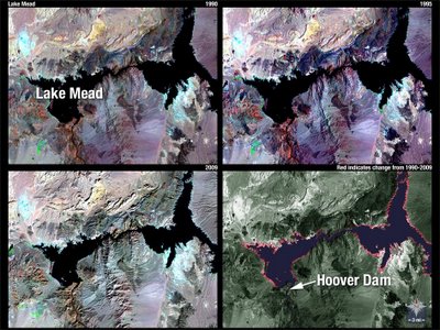
 Lake Mead is the Colorado River Reservoir holding water supplies for California, Arizona, Nevada and the Republic of Mexico. The Landsat photos (left) compare water levels between 1990-2009. The red rim in the lower right image marks the receding water line.
The maximum elevation is 1,229 feet. The closing elevation for July 2009 was 1,094.20. The lake has dropped 31.53 feet in the last five years.
Year-on-year US Bureau of Reclamation comparisons for July going back to 2004:
DATE ELEVATION OF LAKE MEAD
July 31, 2009: 1,094.20
July 31, 2008: 1,104.42
July 31, 2007: 1,111.58
July 31, 2006: 1,126.42
July 31, 2005: 1,139.01
July 31, 2004: 1,125.73
Comments
Leave a Reply


