Disaster denied
“Southern California foothill communities escaped potentially disastrous debris flows from fire-scarred mountains during last week’s storms because total rainfall was far less than expected, the U.S. Geological Survey said Wednesday.”
Click here to keep reading the AP report in the San Francisco Chronicle about how Southern Californian foothill communities were lucky during the last rain, but how they are far from immune to deadly mudslides as the rainy season continues. Via Aquafornia.
Or, if you live in the foothills and you are still thinking about staying in your house the next time a big storm rolls through, click here to read the USGS “Emergency Assessment of Postfire Debris-Flow Hazards for the 2009 Station Fire, San Gabriel Mountains, Southern California”
…
Debris warning for burn areas
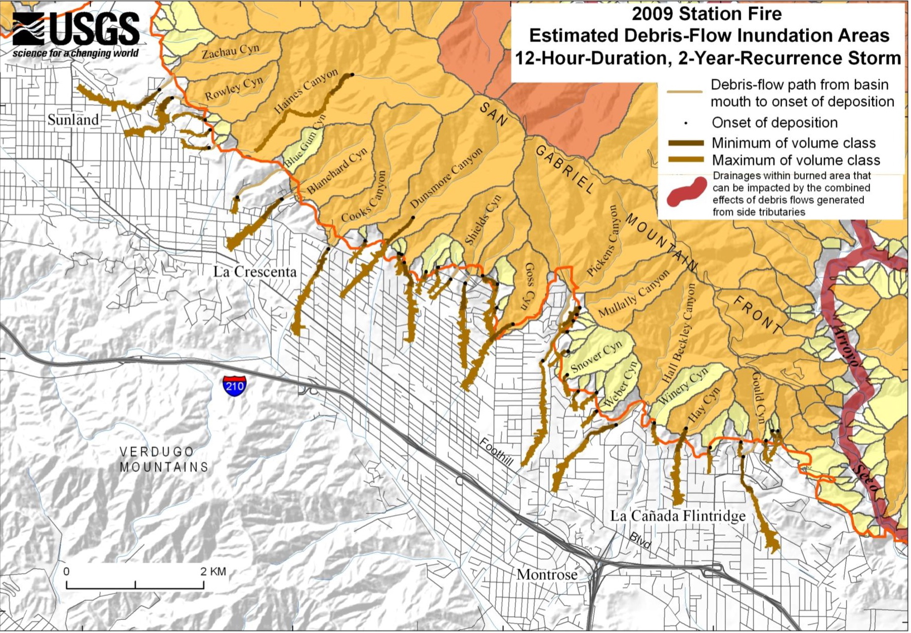
THE US GEOLOGICAL SURVEY today issued winter rain debris-flow warnings for communities at the feet of the San Gabriel Mountains, as well as areas in Big Tujunga Canyon, Pacoima Canyon, Arroyo Seco, West Fork of the San Gabriel River, and Devils Canyon.
For the USGS press release along with further links for landslide preparedness and weather warning systems, click here; for text of the USGS hazard assessment, click here; for the Los Angeles Times report, click here. To enlarge the map, click on the image.
Over at LA Observed, Kevin Roderick harks back to John McPhee’s account of “rock porridge” via a Bernadette Murphy op-ed piece in the LA Times.
If it’s any comfort to those downhill from potential torrents of debris, predictions of an El Nino for Southern California look about as promising for rainfall as another supposed El Nino year, 2006-2007, a record low …
Guiberson fire burn scar
Burn scar from the Guiberson Fire in Ventura County, California, September 26, 2009. Source: NASA. Click on the image to be taken to the original image with background text from the Earth Observatory.
The week that was, 9/13-19/2009
Burn scar from the Los Angeles Station Fire, September 16th, 2009. Photo: NASA. Click on the image to be taken to the Earth Observatory.
Most expenses are never assigned to the bottom-line costs of wildfire. — Comment piece in The Oregonian
By Saturday [September 19th] the arson-caused fire that claimed the lives of two firefighters was 93% contained and had cost nearly $84 million to fight. More than 700 firefighters remain on the fire lines. — Los Angeles Times
Although up to 15 percent of the city of Los Angeles’ water comes from local sources such as the Angeles National Forest, other neighboring communities in the San Gabriel Valley rely on the forest watershed for most of their water. — TreePeople press release
…
Los Angeles fires from the Earth Observatory
From top left to right, these images of the Los Angeles fires were captured on August 29th, August 30th, August 31st, September 2nd, September 3rd, September 6th and September 7th. The second to final image, taken September 6th, uses infrared definition to show the smoldering remains in black of the Los Angeles National Forest. The final one uses colorization to better define burn areas from where fire remains and unburned areas. Click twice on the image for a large version with helpful graphics overlaid.
To be taken to the Earth Observatory, click here.
9/3/2009: For Angelenos who think it’s all about us, it’s not. For information about wildfires burning across the West, click here for the National Interagency Fire Center.
9/15/2009: From NASA: Space Craft Talk Continued during JPL Wildfire Threat: As the flames of the raging brush fire dubbed the Station Fire threatened the northern …
North American Native Plant Societies

After the lawn

Garden blogs
