Two years in Altadena
Posted on | December 3, 2012 | 5 Comments

Two years ago, this was paved. Click on the image for a photo-diary of a two year garden-making project in Altadena, California.
In the aftermath of a storm
Posted on | December 1, 2012 | 4 Comments

Margaret Garcia was one of the dozens of artists who made sculpture from trees toppled in a November 2011 wind storm to benefit the Los Angeles County Arboretum’s tree fund. Click on the image to learn more about Garcia.
A year ago last night thousands of trees fell in Los Angeles as the county was scoured by hurricane force winds. Hardest hit were the foothill cities, such as Arcadia, Sierra Madre, Pasadena and Altadena. This weekend the Los Angeles County Arboretum and Botanic Garden, based in Arcadia, will be displaying artwork made from the remnants of the more than 200 trees toppled across its grounds. The show, curated by Arboretum artist-in-residence Leigh Adams, will benefit the garden’s tree fund.
For information on the show, click here and for a sample photo gallery here. For an article describing the most common causes of tree failure in Los Angeles, here. As climate change rewrites all rules for urban arbors, Los Angeles’s horticultural establishment has yet to grasp the nettle of revising and updating recommended tree lists and reforming planting and irrigation practices. However, for an excellent two-part tree planting guide by Rancho Santa Ana Botanic Garden research associate Barbara Eisenstein, click here and here.
Tags: chance of rain > Emily Green > Los Angeles County Arboretum and Botanic Garden > tree failure
High good, low bad: Mead in November 2012
Posted on | November 30, 2012 | No Comments

Groundwater storage projects and complex water trades look great in graphics and PowerPoints … until you ask to see the cold hard facts. Then you may be treated to a sheet of blank paper. A new report from the Public Policy Institute of California finds that of at least 89 California agencies involved in conjunctive use programs, “fewer than half” complied with state Department of Water Resources requests for quantitative data. “As a result,” write the authors, “the next update of the California Water Plan will be able to offer only broad estimates of banking operations, with incomplete information on key questions relating to the capacity and actual storage levels of the agencies.”
Regular readers of this blog will know that monthly checks on Lake Mead are often departure points. This post is shamelessly hurled with the intent of skipping across the surface of the largest storage reservoir in the US only to bounce onto mentions about groundwater projects where river waters may, improbably, be sunk while long buried aquifers are at the same time targeted for plunder.
At the close of November 2012, Lake Mead was at 51% full of impounded Colorado River water, its elevation roughly 1,117 feet. According to the federal Bureau of Reclamation, the greater Colorado River system is at roughly 56% capacity (down 9% from last year.)
Is this half empty or half full? Las Vegas water manager Pat Mulroy predicted “devastating” news when a two-year study on increasing demands and decreasing supplies of the Colorado River was published this month, except the report is late. Shock and awe will have to wait until December. Click here to keep reading
Tags: Aquifer Storage and Recovery > chance of rain > Emily Green > Lake Mead elevations
‘Red states’ also red on drought map
Posted on | November 15, 2012 | 1 Comment
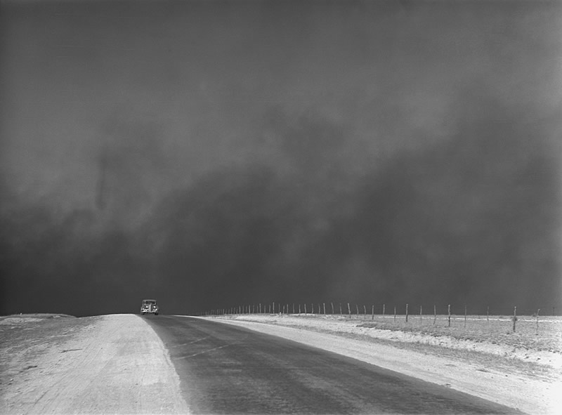
Dust storm in the Texas panhandle, 1936. Photo: Arthur Rothstein via Ken Burns’ “The Dustbowl.” Click on the image to be taken to the site of the new PBS series, which airs this weekend.
Good science is free of politics. Bad politics are free of science. As “red state” legislators conduct a post-mortem on the 2012 election, the smartest and most diligent of them will be crossing the aisle to work with Democratic caucuses to focus on climate change, which these images illustrate is not merely a “blue state” problem in the Sandy-battered Northeast. A good place to start is today’s dispatch from NASA’s Earth Observatory carrying imagery of a November 10 dust storm blowing across the Kansas-Colorado border. The “storm occurred along the Arkansas River, which flows roughly eastward from the Rocky Mountains toward the Mississippi River,” reported NASA.
The storm struck, continued the report, “in the midst of an exceptional drought, according to the U.S. Drought Monitor. By November 2012, the area along the border between Colorado and Kansas had experienced dry conditions for several months, as did a much larger region. In July 2012, the U.S. Department of Agriculture declared the largest natural disaster area in U.S. history due to drought conditions, and this region was part of the disaster area.”
For a previous NASA post about dust storms emanating from the drought-struck Great Plains, click here. For the latest map from the US Drought Monitor, here. Click on the images below to enlarge them. (This post was updated 11/16 to add the Burns documentary photo.)


Tags: chance of rain > Emily Green > NASA Earth Observatory > US Drought Monitor
No news is no news for El Niño prospects
Posted on | November 12, 2012 | No Comments

“As of October 30, 60.2 percent of the contiguous U.S. was experiencing drought conditions with the most severe conditions in the Great Plains,” reports the National Oceanic and Atmospheric Administration in its October 2012 “State of the Climate” summary.
Elsewhere, a recent NOAA update on what had looked like an “El Niño” weather system associated with good rain years in Southern California suggests that the system is petering out. “While the development of El Niño, or even La Niña, cannot be ruled out during the next few months,” reads the November 8 update, ” ENSO-neutral is now favored through the Northern Hemisphere winter 2012-13.”
For an explanation of ENSO, an acronym for El Niño / Southern Oscillation, click here. Crudely shorthanded for those of us in the American Southwest, the adjusted forecast means that we have no prevailing trend of equatorial Pacific Ocean temperatures to give us strong hints about how they will affect weather patterns and whether or not this winter will be a drier or wetter sort of rainy season.
« go back — keep looking »North American Native Plant Societies

After the lawn

Garden blogs
